1. Data

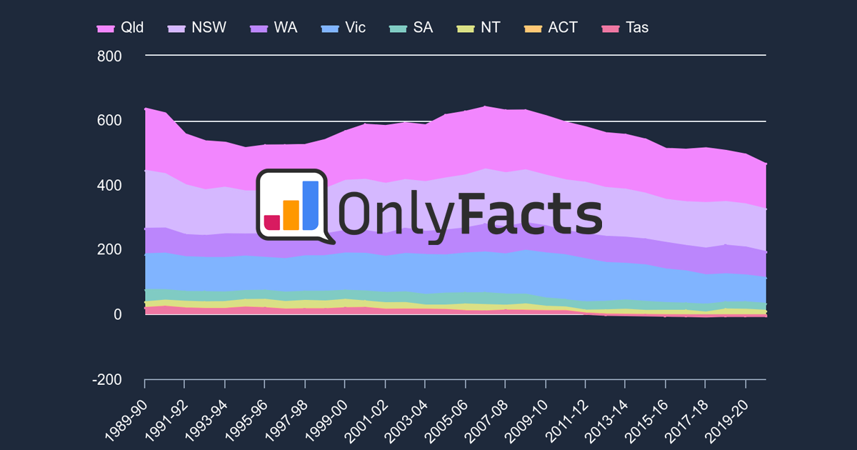
This data excludes emissions from the Land Use, Land-Use Change and Forestry (LULUCF) sector. Here's why. What is Mt CO₂-e? Emissions are a combination of gases. Most are Carbon Dioxide (CO₂). The other gases are measured as a Carbon Dioxide equivalent (CO₂-e) based on the amount of heat they trap in the atmosphere. They’re measured in Million Tonnes (Mt).

Spain

Emissions History (excl. LULUCF) - Pop. 46.75M

spain

Source: PRIMAP-hist via OnlyFacts

Data

Emissions History (excl. LULUCF) - Pop. 46.75M

spain

YEAR

per 100k

Mt CO₂-e

NET

1900 0.052 24.39 -
1901 0.054 25.12 3.0%
1902 0.055 25.85 2.9%
1903 0.055 25.67 0.7%
1904 0.057 26.72 4.1%
1905 0.059 27.44 2.7%
1906 0.059 27.81 1.3%
1907 0.060 28.19 1.4%
1908 0.062 29.02 2.9%
1909 0.063 29.52 1.7%
1910 0.063 29.25 0.9%
1911 0.062 29.10 0.5%
1912 0.066 30.64 5.3%
1913 0.069 32.35 5.6%
1914 0.069 32.33 0.1%
1915 0.064 30.07 7.0%
1916 0.071 33.11 10.1%
1917 0.066 30.87 6.8%
1918 0.068 32.00 3.7%
1919 0.067 31.19 2.5%
1920 0.062 28.93 7.2%
1921 0.064 30.06 3.9%
1922 0.065 30.42 1.2%
1923 0.071 33.18 9.1%
1924 0.074 34.77 4.8%
1925 0.076 35.72 2.7%
1926 0.075 35.08 1.8%
1927 0.083 38.81 10.6%
1928 0.084 39.12 0.8%
1929 0.090 42.12 7.7%
1930 0.089 41.73 0.9%
1931 0.087 40.55 2.8%
1932 0.084 39.18 3.4%
1933 0.078 36.48 6.9%
1934 0.082 38.19 4.7%
1935 0.088 40.92 7.1%
1936 0.053 24.79 39.4%
1937 0.047 21.78 12.1%
1938 0.067 31.27 43.6%
1939 0.074 34.47 10.2%
1940 0.089 41.49 20.4%
1941 0.090 41.89 1.0%
1942 0.094 44.15 5.4%
1943 0.098 45.74 3.6%
1944 0.104 48.65 6.4%
1945 0.111 52.05 7.0%
1946 0.113 52.61 1.1%
1947 0.120 56.30 7.0%
1948 0.126 58.82 4.5%
1949 0.134 62.85 6.9%
1950 0.129 60.47 3.8%
1951 0.131 61.13 1.1%
1952 0.143 66.66 9.1%
1953 0.147 68.81 3.2%
1954 0.150 70.33 2.2%
1955 0.153 71.62 1.8%
1956 0.159 74.48 4.0%
1957 0.180 83.95 12.7%
1958 0.194 90.88 8.3%
1959 0.187 87.53 3.7%
1960 0.182 84.91 3.0%
1961 0.197 92.11 8.5%
1962 0.213 99.34 7.8%
1963 0.211 98.69 0.7%
1964 0.224 104.87 6.3%
1965 0.240 112.27 7.1%
1966 0.257 120.09 7.0%
1967 0.279 130.52 8.7%
1968 0.305 142.76 9.4%
1969 0.309 144.44 1.2%
1970 0.350 163.53 13.2%
1971 0.376 175.69 7.4%
1972 0.414 193.47 10.1%
1973 0.439 205.36 6.1%
1974 0.479 224.12 9.1%
1975 0.496 231.89 3.5%
1976 0.535 249.88 7.8%
1977 0.530 247.54 0.9%
1978 0.546 255.34 3.2%
1979 0.552 257.98 1.0%
1980 0.576 269.02 4.3%
1981 0.557 260.54 3.2%
1982 0.567 265.17 1.8%
1983 0.552 258.10 2.7%
1984 0.544 254.07 1.6%
1985 0.547 255.91 0.7%
1986 0.530 247.63 3.2%
1987 0.529 247.26 0.1%
1988 0.551 257.44 4.1%
1989 0.609 284.79 10.6%
1990 0.614 286.99 0.8%
1991 0.630 294.45 2.6%
1992 0.652 304.62 3.5%
1993 0.628 293.64 3.6%
1994 0.665 310.71 5.8%
1995 0.700 327.18 5.3%
1996 0.681 318.14 2.8%
1997 0.712 332.84 4.6%
1998 0.733 342.41 2.9%
1999 0.788 368.12 7.5%
2000 0.820 383.20 4.1%
2001 0.815 380.91 0.6%
2002 0.855 399.87 5.0%
2003 0.872 407.55 1.9%
2004 0.905 422.96 3.8%
2005 0.937 437.85 3.5%
2006 0.923 431.55 1.4%
2007 0.946 442.29 2.5%
2008 0.874 408.38 7.7%
2009 0.788 368.32 9.8%
2010 0.755 353.16 4.1%
2011 0.755 353.09 0.0%
2012 0.739 345.64 2.1%
2013 0.682 318.76 7.8%
2014 0.686 320.61 0.6%
2015 0.709 331.63 3.4%
2016 0.684 319.63 3.6%
2017 0.712 332.66 4.1%
2018 0.696 325.43 2.2%
2019 0.656 306.80 5.7%
2020 0.576 269.03 12.3%
2021 0.611 285.57 6.1%
2022 0.628 293.53 2.8%

Source: PRIMAP-hist via OnlyFacts

News

Sign up to the free weekly climate data briefing